
Pacific Crest Trail Extension: BC
Step 1: Determining Trail Preferences
It was first necessary to determine what features were the most and least desirable in determining a suitable path. Preferably, the path will avoid crossing roads, large water bodies, and urban and industrial areas in favour of more natural landscapes.
The minimization of extremely steep trail slopes - especially upward inclines - was also an important factor to be considered.
Particular places of interest were chosen as mandatory points for the trail to cross, these points were all located within provincial parks (Garibaldi, Tsilos, and Tweedsmuir). At each of these points there is nearby access to food and human contact. In addition to these points, it is occasionally necessary for the path to either cross, or come in close proximity to either road access or a settled environment. These points provide additional trail access and resupply locations.


Step 2: Constructing a Cost Surface
In order to incorporate these preferences into identifying the most preferable trail, a cost raster must be created.
To create the cost raster, or frictional surface, costs were assigned to different land-use types in our land-use dataset. These values were created to reflect the preference of crossing one land use type versus another. Most preferred land use types for the trail are reflected by lower values.
(1) Alpine, sub alpine, and barren surfaces
(1) Forests
(100) Snow & glaciers
(200) Agricultural & Range Lands
(450) Recreational activities, residential agriculture mixtures and urban
(500) Estuaries, fresh water, salt water, and wetlands
(1000) Mining
This data was combined with layers that included streams and roads.
(50) Streams
(400) Roads - Buffers of 1km were used in order to maintain a preferable distance for hiking
Using the Conditional Tool, these features were combined so that streams would override land use costs, and roads would override all other features. This was done to prevent costs from being combined in a common raster cell.

Data Used
Abacus: BC DEM_77m
UBC Server: BC Rivers, BC Roads
DataBC: Baseline Thematic Mapping Present Land Use Version 1 Spatial Layer
Projection Coordinate System: BC Albers Equal Area Conic
Methods
Step 3: Path Distance Analysis
By using the Path Distance tool, we were able to combine our friction surface with elevation data. By using this tool, we were able to account for resistance to slope in our path distance map creation. This was done by incorporating a vertical factor that calculated resistance to slope as an inverse linear function. In this case, negative slopes moving away from the trailhead were less of an obstacle than positive slopes. A maximum slope of ±30 degrees was used to completely restrict travel over extremely steep terrain. Furthermore, as opposed to measuring distance on a flat surface, this tool was able to incorporate the actual distance of travel between cells over varying elevation.
Using the Cost Path tool, we were then able to find the most suitable path segments from the trailhead to the finish, via each predetermined point of interest.
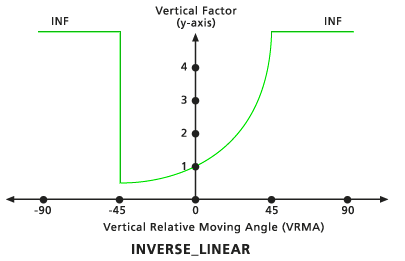
Vertical Factor as an Inverse Linear Function
ArcGIS Desktop Help 10.1